Planning Services (includes all permitting-related activities)
Please email inquiries to This email address is being protected from spambots. You need JavaScript enabled to view it.
The Front Desk at Town Hall is open weekdays from 8:30am-4:30pm 902-634-4410. Meetings must be pre-arranged by appointment. To book an appointment, contact staff.
Service Standard Time:
Staff will strive to respond to inquiries within 2 business days. Inquiries that require additional research may take longer, however, a staff person will be in touch to notify you of expected turnaround times.
Please note: Email inquiries with detailed information on your request are preferred
- Strategy & By-Laws: For details on the Municipal Planning Strategy, Land Use By-Law and others including downloads, click here.
- Permits: For types of permits and applications, click here.
- Public consultation is an integral part of many Planning projects. The Public Participation Policy for Planning matters outlines the process, or click here.
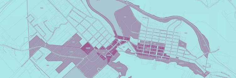
Town of Lunenburg Land Use
 Online Zoning Look-up Map
The Town of Lunenburg has developed an online tool to assist residents and businesses in finding what zones apply to their property under the new three-layer lot/form/use designations in the 2021 Land Use Bylaw. To look up a property, use the street address, property ID number, or simply click on the interactive map. Visit the Town of Lunenburg Online Zoning Look-up.
For details on the Land Use By-law, visit: https://townoflunenburg.ca/strategy-and-by-laws.html
Municipal Climate Change Action Plan
A Municipal Climate Change Action Plan (MCCAP) was completed by the Town of Lunenburg in February 2015. The MCCAP is divided into two sections including Adaptation and Mitigation. This plan is a means of considering climate change impacts within the Town boundaries. Planning enables the Town, residents, businesses and developers to better respond to climate change, reduce risk and minimize damage. The purpose of the MCCAP is to proactively plan for climate change and identify where adaptation and mitigation measures are necessary to improve public safety and community sustainability. The Town also hired a consultant to prepare a higher-resolution map showing the impact of sea-level rise and storm surge levels in the years 2025 and 2100. Both these documents can be viewed by clicking on the links provided below.
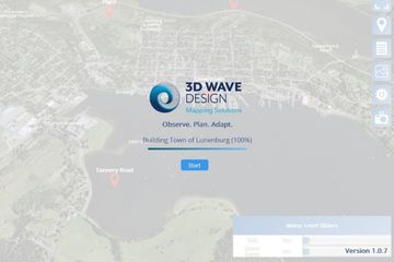 Interactive Flood Model
With accelerated sea level rise due to climate change, the Town of Lunenburg worked with 3D Wave Design to create a visualizing tool that allows projection using factors like date, tide, storm surge, etc. to assist with flood mitigation planning. Visit the Lunenburg Interactive Flood Map online. (Please note it takes a few minutes to load!)